One Vision, Zero Fatalities. #DotteProud
The Wyandotte County Vision Zero Action Plan (VZAP) is a bold initiative to eliminate fatal and serious injury crashes in Kansas City, Kansas, and Wyandotte County. Funded by a U.S. Department of Transportation (USDOT) grant, this plan uses crash data and public input to identify high-risk areas and develop safety strategies for all road users.
Together, we can create a safer Wyandotte County.
Introduction to Vision Zero
Read the Latest
UG Vision Zero Steering Committee Tours Wyandotte County

Published on May 27, 2025
Recently, a group of area stakeholders representing diverse sectors, including the KCKFD, KCK, Piper, and Turner school districts, Children’s Mercy Hospital, The Whole Person, the Metropolitan Organization to Counter Sexual Assault (MOCSA), the City of Bonner Springs, and various departments within the Unified Government, participated in a Vision Zero Action Plan “Safety Tour” of the county.
Tagged as: , Announcements, Business & Economy, Community Safety, Infrastructure, Media Releases
Upcoming events:
- August 15th 11:00 AM - 12:00 PM – Presentation at Shepherd's Center, 3333 Wood Ave, Kansas City, KS 66102
- August 23rd Time TBD - Tabling at Bonner Springs Tiblow Days, Downtown Bonner Springs, KS
- September 9th 6:30 PM - Presentation at Frank Rushon Neighborhood Association, 4326 Lloyd, Kansas City, KS
Request a speaker– Would you like to learn more or request a presentation on the Vision Zero Action Plan? Or would you like to host us at your community meeting or event? Email Long Range Planner Alyssa Marcy at amarcy@wycokck.org with comments or questions.
What is the Vision Zero Action Plan?
Funded by a USDOT grant, this Vision Zero Action Plan (VZAP) will be Wyandotte County’s foundational document to improve roadway safety on our streets and work toward a vision of zero fatalities and serious injuries from traffic crashes. Using years of crash data from the Kansas Department of Transportation, as well as input from the general public and key community stakeholders, it will identify the streets and intersections in our community most in need of safety improvements. This effort will identify the most important focus area for roadway safety in Wyandotte County – for example, impaired driving, speeding, and pedestrian safety. From there, we’ll develop strategies to help us achieve our vision, along with definable actions and performance measures to track our progress.

The VZAP will be created in collaboration with the Unified Government of Wyandotte County and Kansas City, Kansas, and partner Cities of Bonner Springs and Edwardsville. Ultimately, the Wyandotte County Vision Zero Action Plan will provide a roadmap for how the community can eliminate traffic deaths and serious injuries on its streets through improving roadway safety, updating policies to prioritize safety, and equitable and inclusive community engagement.
What are the Plan Goals?
The Wyandotte County Vision Zero Action Plan goals will be developed through the planning process and guided by a Steering Committee of representatives from organizations and agencies from around the County. The Wyandotte County Vision Zero Plan will focus on:
-
All Modes of Transportation – eliminate traffic deaths for people walking, biking, and driving.
-
Equity – focus on equitable safety solutions prioritized to the areas of greatest need to ensure safe access is available to everyone.
-
Data-Driven Solutions – based on industry best practices, evidence-based solutions, and local data analysis.
-
Public Input – guided by feedback from the public.
-
Education – inform the public of the importance of Vision Zero and a shared responsibility of all roadway users and county officials,
-
Commitment & Accountability – gain buy-in at all levels of leadership and guide alignment of funding, policies, and processes.
-
Urgency – focus on quick action to address the urgent need to stop the continued loss of life and severe injuries.
What We Heard
An online comment map asked Wyandotte County residents to share your transportation safety concerns and locations you feel to be particularly unsafe while walking, biking, driving, or otherwise getting around. This information will help to inform the ongoing work of the Vision Zero Action Plan. Over a period of 5 months, we received over 450 comments about safety concerns on our roadways. Major concerns included:
- Lack of sidewalks
- Crosswalks not being visible/clearly marked
- Trees and parked cars obstructing visibility
- Traffic controls making yielding/turning unsafe
- Drivers speeding excessively over posted limit, especially in residential/school zones
- Transit stops lacking pedestrian access

What does the data say?
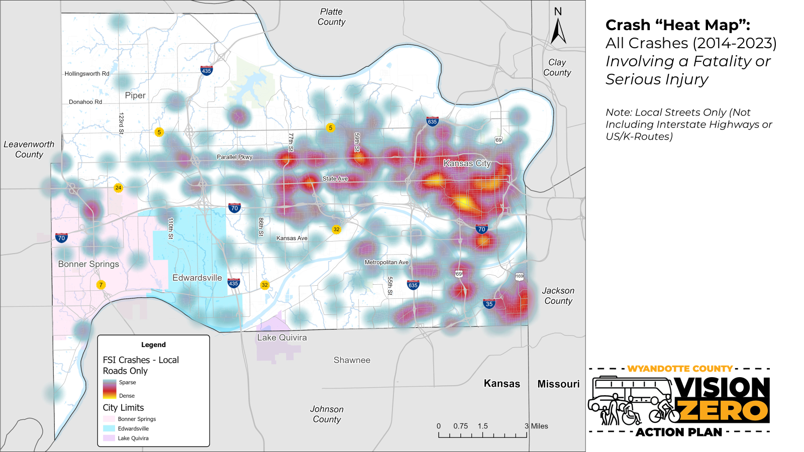
The VZAP is, at its core, an in-depth review of all traffic related fatalities and serious injuries in Wyandotte County. Our team reviewed local, state, and federal data - such as crash reports and roadway traffic conditions - to identify the most unsafe roadways and intersections experienced by residents and visitors alike. The heat map below illustrates all crashes on local streets only (i.e. no state or federal highways) involving a fatality or serious injury between 2014-2023:
 (PNG, 1MB)